![](/images/other/stat-length.png)
![Randonnée Marche Le Valtin - col de la schlucht, kerbhalz - Photo](https://media.geolcdn.com/t/1900/400/ext.pjpeg?maxdim=2&url=https%3A%2F%2Fstatic1.geolcdn.com%2Fsiteimages%2Fupload%2Ffiles%2F1553511878bg_sport_marche.png)
col de la schlucht, kerbhalz
grattounette
Utilisateur
![Longueur](/images/other/stat-length.png)
Longueur
22 km
![Altitude max](https://static1.geolcdn.com/siteimages/upload/files/1508320355ic_sort_altitude_max_24dp.png)
Altitude max
1355 m
![Dénivelé positif](https://static1.geolcdn.com/siteimages/upload/files/1508320355ic_sort_den_pos_24dp.png)
Dénivelé positif
1148 m
![Km-Effort](/images/other/stat-length.png)
Km-Effort
37 km
![Altitude min](https://static1.geolcdn.com/siteimages/upload/files/1508320355ic_sort_altitude_min_24dp.png)
Altitude min
806 m
![Dénivelé négatif](https://static1.geolcdn.com/siteimages/upload/files/1508320355ic_sort_den_neg_24dp.png)
Dénivelé négatif
1152 m
![Boucle](https://static1.geolcdn.com/siteimages/upload/files/16400158638029165_repeat_loop_refresh_sync_direction_icon.png)
Boucle
Oui
Date de création :
2015-08-03 00:00:00.0
Dernière modification :
2015-08-03 00:00:00.0
![Marche](https://static1.geolcdn.com/sitytour/trail-icons/101.png)
9h25
Difficulté : Difficile
![Scannez ce code QR pour ouvrir la randonnée dans l'application SityTrail](https://capi.geolives.com/qq0zvz2zws4bq2lad0pu/sitytour/trails/453497/qr.png?size=200)
Application GPS de randonnée GRATUITE
À propos
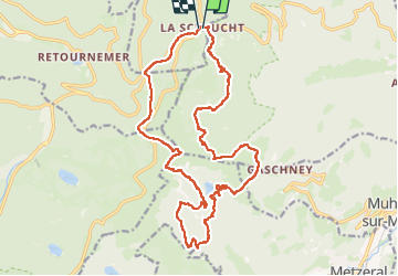
Randonnée Marche de 22 km à découvrir à Grand Est, Vosges, Le Valtin. Cette randonnée est proposée par grattounette.
Description
col de la schlucht, sentier des roches, frankental, le petit hohneck, schiessroth, lac de schiessrothried, lac de fischboedle, kerbhalz, retour GR531 le hohneck, le haut chitelet, refuge du sotre, le collet
Localisation
Pays :
France
Région :
Grand Est
Département/Province :
Vosges
Commune :
Le Valtin
Localité :
Unknown
Départ:(Dec)
Départ:(UTM)
352693 ; 5325290 (32U) N.
Commentaires
Randonnées à proximité
![Randonnée Marche Stosswihr - Tour du belvedere avec le passage sur les crêtes - Photo](https://media.geolcdn.com/t/375/260/ext.jpg?maxdim=2&url=https%3A%2F%2Fmedia.geolcdn.com%2Ff%2F5b3c85c1-2643-45e9-9769-80e100e05dda.jpg)
![Marche Marche](https://static1.geolcdn.com/sitytour/trail-icons/101.png)
Tour du belvedere avec le passage sur les crêtes
Marche
Très facile
(2)
Stosswihr,
Grand Est,
Haut-Rhin,
France
![](/images/other/stat-length.png)
8,5 km | 0 m-effort
2h 28min
![](https://static1.geolcdn.com/siteimages/upload/files/16400158638029165_repeat_loop_refresh_sync_direction_icon.png)
Oui
![Randonnée Autre activité Soultzeren - Totom 4 lacs - Photo](https://media.geolcdn.com/t/375/260/ext.jpg?maxdim=2&url=https%3A%2F%2Fservices.sitytrail.com%2FGeolivesWS%2FDownloadMedia.ashx%3FTrailID%3D789048%26Media%3D20170713134427.jpg)
![Autre activité Autre activité](https://static1.geolcdn.com/sitytour/trail-icons/900.png)
Totom 4 lacs
Autre activité
Moyen
(1)
Soultzeren,
Grand Est,
Haut-Rhin,
France
![](/images/other/stat-length.png)
15,6 km | 26 km-effort
4h 37min
![](https://static1.geolcdn.com/siteimages/upload/files/16400158638029165_repeat_loop_refresh_sync_direction_icon.png)
Oui
![Randonnée Marche La Bresse - Les 5 lacs autour du Hohneck - Photo](https://media.geolcdn.com/t/375/260/ext.jpg?maxdim=2&url=https%3A%2F%2Fmedia.geolcdn.com%2Ff%2F1aca13ab-a2d4-4f36-9908-21034b2a8a3e.JPG)
![Marche Marche](https://static1.geolcdn.com/sitytour/trail-icons/101.png)
Les 5 lacs autour du Hohneck
Marche
Très difficile
(1)
La Bresse,
Grand Est,
Vosges,
France
![](/images/other/stat-length.png)
21 km | 36 km-effort
7h 21min
![](https://static1.geolcdn.com/siteimages/upload/files/16400158638029165_repeat_loop_refresh_sync_direction_icon.png)
Oui
![Randonnée Marche Le Valtin - Les Hirschsteine - Photo](https://media.geolcdn.com/t/375/260/ext.jpg?maxdim=2&url=https%3A%2F%2Fservices.sitytrail.com%2FGeolivesWS%2FDownloadMedia.ashx%3FTrailID%3D311037%26Media%3Dfix__20140608114301.jpg)
![Marche Marche](https://static1.geolcdn.com/sitytour/trail-icons/101.png)
Les Hirschsteine
Marche
Difficile
(1)
Le Valtin,
Grand Est,
Vosges,
France
![](/images/other/stat-length.png)
16,1 km | 25 km-effort
6h 28min
![](https://static1.geolcdn.com/siteimages/upload/files/16400158638029165_repeat_loop_refresh_sync_direction_icon.png)
Oui
![Randonnée Marche Ban-sur-Meurthe-Clefcy - La vallée de Belbriette - Ban-sur-Meurthe-Clefcy - Photo](https://media.geolcdn.com/t/375/260/ext.jpg?maxdim=2&url=https%3A%2F%2Fservices.sitytrail.com%2FGeolivesWS%2FDownloadMedia.ashx%3FTrailID%3D172951%26Media%3D14431_5.jpg)
![Marche Marche](https://static1.geolcdn.com/sitytour/trail-icons/101.png)
La vallée de Belbriette - Ban-sur-Meurthe-Clefcy
Marche
Moyen
(2)
Ban-sur-Meurthe-Clefcy,
Grand Est,
Vosges,
France
![](/images/other/stat-length.png)
9,8 km | 12,6 km-effort
2h 30min
![](https://static1.geolcdn.com/siteimages/upload/files/16400158638029165_repeat_loop_refresh_sync_direction_icon.png)
Oui
![Randonnée Marche La Bresse - Du Hohneck au Kastelberg par les Spietzkoepfe et le Sentier des Névées - Photo](https://media.geolcdn.com/t/375/260/ext.jpg?maxdim=2&url=https%3A%2F%2Fservices.sitytrail.com%2FGeolivesWS%2FDownloadMedia.ashx%3FTrailID%3D110319%26Media%3D5746_5.jpg)
![Marche Marche](https://static1.geolcdn.com/sitytour/trail-icons/101.png)
Du Hohneck au Kastelberg par les Spietzkoepfe et le Sentier des Névées
Marche
Très difficile
(3)
La Bresse,
Grand Est,
Vosges,
France
![](/images/other/stat-length.png)
7,6 km | 13,7 km-effort
3h 30min
![](https://static1.geolcdn.com/siteimages/upload/files/16400158638029165_repeat_loop_refresh_sync_direction_icon.png)
Oui
![Randonnée Marche Soultzeren - Tanet-Gazon du faing par lac vert et retour sommet du Tanet - Photo](https://media.geolcdn.com/t/375/260/ext.jpg?maxdim=2&url=https%3A%2F%2Fmedia.geolcdn.com%2Ff%2Fed68be74-246f-440b-833e-a0b4a96a4c20.jpg)
![Marche Marche](https://static1.geolcdn.com/sitytour/trail-icons/101.png)
Tanet-Gazon du faing par lac vert et retour sommet du Tanet
Marche
Moyen
(1)
Soultzeren,
Grand Est,
Haut-Rhin,
France
![](/images/other/stat-length.png)
10 km | 15,6 km-effort
4h 24min
![](https://static1.geolcdn.com/siteimages/upload/files/16400158638029165_repeat_loop_refresh_sync_direction_icon.png)
Oui
![Randonnée Raquettes à neige Le Valtin - raquettes - Photo](https://media.geolcdn.com/t/375/260/ext.jpg?maxdim=2&url=https%3A%2F%2Fservices.sitytrail.com%2FGeolivesWS%2FDownloadMedia.ashx%3FTrailID%3D531361%26Media%3Dfix__20160228130536.jpg)
![Raquettes à neige Raquettes à neige](https://static1.geolcdn.com/sitytour/trail-icons/504.png)
raquettes
Raquettes à neige
Très facile
(1)
Le Valtin,
Grand Est,
Vosges,
France
![](/images/other/stat-length.png)
6,6 km | 9,4 km-effort
3h 8min
![](https://static1.geolcdn.com/siteimages/upload/files/16400158638029165_repeat_loop_refresh_sync_direction_icon.png)
Non
![Randonnée Marche Stosswihr - Le cirque glaciaire du Frankenthal - Sentier des Roches -Gps - Photo](https://media.geolcdn.com/t/375/260/ext.jpg?maxdim=2&url=https%3A%2F%2Fstatic1.geolcdn.com%2Fsiteimages%2Fupload%2Ffiles%2F1553511878bg_sport_marche.png)
![Marche Marche](https://static1.geolcdn.com/sitytour/trail-icons/101.png)
Le cirque glaciaire du Frankenthal - Sentier des Roches -Gps
Marche
Difficile
(3)
Stosswihr,
Grand Est,
Haut-Rhin,
France
![](/images/other/stat-length.png)
9 km | 16,1 km-effort
4h 10min
![](https://static1.geolcdn.com/siteimages/upload/files/16400158638029165_repeat_loop_refresh_sync_direction_icon.png)
Oui